Thursday, January 2, 2014

Our St. Patty's Shirt's Are Ready To Sell

We launched our t-shirt campaign today for our Schuylkill County Irish!  The great thing about this sale is now we have men's and women's styles.  You can get them at link below.  Once on that page, click the drop-down box labeled "Style" to see the shirt in different styles.

http://teespring.com/irishskook2

Men's
Women's V-neck

Midday Weather Update

Click Pic to View Larger
By:  Monsoon Mike

If you're watching the Scranton TV stations, you're already seeing some schools closing on the screen crawl and wondering why given the snow is not set to begin over much of the Monsoon Mike's Weather Headquarters area until later this afternoon. Well, it's because of what I mentioned yesterday. Advection snowfall is already happening ahead of the main storm especially in higher elevations and north of Interstate 80. This radar map picture from 10:45 a.m. shows that quite nicely. The entire state will fill in with snowfall later this afternoon, but not before I think most kids make it home from school safely. For you adults, however, if you're working past 5 p.m., I'd prepare for a potentially rough ride home

Water Boil Advisory Cancelled - Fountain Springs/Country Club Estates

The following has just been posted to Ashland Borough's Facebook page

WATER BOIL ADVISORY CANCELLED The Water Boil Advisory for Fountain Springs and Country Club Estates has been cancelled. The required sampling and testing of the water system has been conducted. The test results have indicated no presence of harmful bacteria. These tests demonstrate that the quality of your drinking water was not affected by the water main break and that it is safe for human consumption.

Schuylkill County School Early Dismissals - 1/2/14


Schuylkill County School Early Dismissals - 1/2/14

Grey Goose Bar, McAdoo Fire, Man in Custody

From TamaquaArea.com

Emergency responders were called around 12:20 AM today (Jan. 2, 2014) to 94 North Kennedy Drive (SR309) in McAdoo for a fully engulfed structure fire.

Overnight Fire in Quakake Displaces Family

From TamaquaArea.com

Firefighters responded to 4 East Main Street just before midnight last night (Jan. 1, 2014) for a report of a house fire. Firefighters were quick to respond and extinguish the fire. Fire was said to be caused by a clothes dryer.

Wednesday, January 1, 2014

Schuylkill County Weather Forecast

Click Picture to View Larger
By:  Monsoon Mike

Winter Weather Advisory Issued For Schuylkill County

WINTER WEATHER ADVISORY IN EFFECT FROM NOON THURSDAY TO 7 AM EST FRIDAY...

THE NATIONAL WEATHER SERVICE IN STATE COLLEGE HAS ISSUED A WINTER WEATHER ADVISORY FOR SNOW...WHICH IS IN EFFECT FROM NOON THURSDAY TO 7 AM EST FRIDAY.

Schuylkill County Weather Update

By: Monsoon Mike

Morning Update:

Good Morning & Happy New Year Everyone! Already folks asking me if the snow tomorrow will give them and their kids a bonus day off from school/work. Unfortunately, I don't think so for most of us. That's not to say Skook won't see snow, but this is a very tricky storm where those areas and areas north of I-80 will have a light snow going most of tomorrow from some atmospheric advection, but areas south of there (Pottsville/Reading/Lehigh Valley/etc.) may not have any decent snow beginning until much later in the afternoon tomorrow. I think a general 1 to 4 inches on a line from Harrisburg to Pottsville will be the final snowfall accumulation when this wraps up Friday morning. Then farther east into the Lehigh Valley and north into northern Jersey, perhaps 3 to 5 or 4 to 6 inches as they'll be more energy there as the storm wraps up along the coast. See my map for what I expect across Skook. Not a crippling storm by any means, but as we know, us eastern Pennsylvanians can't drive in sunshine let alone a little snow, so expect the evening rush tomorrow and definitely the morning rush Friday to be less than desirable. Then some of the most intense cold since several years ago rushes in behind the storm. Lows Friday night will be subzero in many areas!!


Overnight Fire in Ashland, Reported to Be Started By Homeowner

Around 1:30am Wednesday, Ashland Police were called to 1331 Walnut Street, Ashland, after a neighbor called police for the owner of 1331 was causing a disturbance and was throwing contents from the house into the street.

Tuesday, December 31, 2013

Schuylkill County Weather Forecast


By:  Monsoon Mike

Happy New Year to all my readers!

Two big stories in our forecast are snow on Thursday and extreme cold to end the week. The cold I'm certain about. The snow, not so much.

Models have considerably backed off on what they yesterday thought was going to be a major snowstorm, much as I thought would happen given the lack of true atmospheric blocking.

The result I think will be a general 1 to 3 or 2 to 4 inches across the region on Thursday and Friday. Key times Thursday p.m. into early Friday a.m. With the fickle nature of the models on this storm, however, I only give this forecast about a 60 percent certainty at this point. Be sure to follow my fan page for the latest updates.

Following this fairly minor to low-end moderate snowfall will be some of the coldest air we've seen in this area for quite a while. Expect subzero lows and highs barely out of the single digits and teens to wrap up the week!

Officials Sworn in Today At Courthouse


This morning, two elected Schuylkill County Officials were sworn in.

Both John Domalakes and Christine Holman were sworn in.

John Domalakes was sworn in as the Schuylkill County Judge after retaining his  position in the November election. 

Christine Holman was sworn in as the new Schuylkill County District Attorney.

The images below are from Christine Holman's swearing in.


Pictures from L David Truskowsky

One Person Killed on Interstate 81 Crash

Mahanoy City crews were called to the Southbound Milemarker 129.5 Tuesday morning for a crash with ejection.

One person has been confirmed to have died in the crash.  They were pronounced dead by Schuylkill County Deputy Coroner David Truskowsky.

State Police are reported to be investigating the crash.

WNEP is reporting that the man who died was Ralph Rumbel of Ringtown.

3 Alarm Fire Destroys Homes in Shenandoah

Photo from Schuylkill County Firewire
Around 10am, crews were called to 112 South Grant St. Shenandoah for a structure fire.  When crews arrived they found heavy fire in the rear of the structure.  The home was said to be unoccupied.

The fire also spread to another unoccupied home at  110 South Grant and to 114 South Grant Street which was occupied.

The fire call originally came in with entrapment but that turned out to be false.

One dog was rescued from the occupied home.

The fire hit a 3rd alarm after crews needed additional help from around the area for assistance.

No cause has been determined for the blaze at this time.

Monday, December 30, 2013

Schuylkill County Weather Forecast


By:  Monsoon Mike

Ok Ok Ok! Time for Monsoon Mike's Weather Headquarters to bring some reason into mass hysteria that seems to have broken out this afternoon on some of the competing weather boards. The excitement stems from the fact that the one holdout model on the storm has suddenly jumped on board with a major snowstorm for Thursday and because of that, Monsoon Headquarters hotlines have been bombarded with calls, messages, and texts this afternoon asking if I am on board. The answer is maybe, but not quite. (Don't you love how us weather gurus talk?) LOL 

Seriously, the GFS coming on board today is convincing, however, let me say this loud and clear: WE ARE STILL THREE DAYS OUT. It seriously concerns me when there is model consensus three days out. There are at least 10+ more model runs before the snow even starts falling and as good weather prognosticators, we have to put computers aside sometimes and use reason. The lack of a pure blocking pattern STILL indicates to me that this WON'T be a huge event for us. 2 to 4 inches? 3 to 6? Sure. Quite possible. Huge snowstorm? Doubtful. Nevertheless, you know the old joke of the guy in the flood who ignored a rescue boat, rescue helicopter, etc. saying "God will take care of me" and then wound up dying and said to God "why didn't you take care of me" and God said "heck, I sent you a boat and a helicopter." LOL Well, along those lines, I can't ignore these quite convincing signs of a potential good snowstorm, so I am not ignoring them. I'm just being quite cautious at this point. 

Talk to you again New Year's Eve!

The Restaurant/Organization Voted Best Breakfast in Schuylkill County is . . . .

Over the weekend, we polled our followers on our Facebook page and asked our readers:

What restaurant/organization serves the best breakfast in Schuylkill County?

(Drum roll please) And the winner is:

Attention Pine Grove Area - 345 Exchange - 911 is down

If you know someone in the Pine Grove area, in the 345 exchange, who may not be a Facebook user, please contact them and let them know that their "911" system is down. For any emergency they need to call direct to their local fire company, or contact the 911 center at 570-628-3792. Even if they do use Facebook, share this post on their page just to help make sure they get the info!

Sunday Afternoon Fire in Minersville

Fire crews were called Sunday to a home on Pine Hill Street in the Minersville yesterday afternoon around 3PM.

The fire is said to have started in 524 but spread to the other homes on each side.

9 people were displaced in the fire, the homes were a double-block, 2 from one home, 4 from the other, the fire caused heavy damage to another home melting the siding.

No word has been what started the fire but they believe it started on the ground floor.

Fire crews from Minersville, Pottsville, Schuylkill Haven, Yorkville, and Llewellyn fought the blaze.

Sunday, December 29, 2013

Schuylkill County Weather Forecast


By:  Monsoon Mike

Today would probably have to go down as one of the top 10 ugliest days of 2013. Plenty of cold rain with just a few degrees too warm to make it a nice, pretty snowstorm. Fog. Dark clouds. Biting wind. 

Things markedly improve Monday with the return of some sunshine but not the return of the mild temperatures experienced Saturday. In fact, we stay stuck in the 20s and 30s for as far as the eye can see. 

Something ELSE that the eyes are seeing is a potential storm Thursday. Many of my fellow weather gurus are hyping this one, saying things like "we're getting ready to sound the alarm!" Well, no alarms are sounding here at Monsoon Mike's Weather Headquarters. I stand by my call from earlier today that I think the storm doesn't blow into a full-fledged snowstorm until it is past us. Will we still have a storm of some sort? Quite probably yes. Will we still have to shovel? Quite probably yes. Will this be one of the bigger storms in recent history? No. Highly doubtful. But I'm always the first to bow down to my mistakes so if this changes, you'll be the first to know.

Go EAGLES! (There, I said it. Hope I didn't lose any fans ;-) 

Water Boil Advisory

The Borough of Ashland has issued a water boil advisory for Fountain Springs and Country Club Estates until further notice.

Saturday, December 28, 2013

Schuylkill County Weather Forecast


By:  Monsoon Mike

A good dose of rain is in the cards for Sunday. Any threat for frozen precipitation should only be in areas near I-80 & at the tail end.

Cold air works in Monday and some snow showers are possible New Year's Eve. Our next storm potential is around Thursday & if it happened, it would be white & not wet. But right now the certainty of a Thursday snow event is only at about 35% (Monsoon Mike 2035)

Friday, December 27, 2013

Schuylkill County Weather Forecast

By:  Monsoon Mike

Nice Saturday upcoming with temperatures a bit above normal, but that'll be short-lived as a soggy Sunday is in the cards. Recent trends now limit yesterday's concern for mixed precipitation at the start and finish. Still wouldn't rule some mixing out in normally colder locations, but this will be a 95% rain event. 

Then a good shot of cold air rushes in behind the storm just in time for New Years'. Beyond that, looking pretty cold and perhaps a storm or two up my sleeve in early 2014. At they say in the old time radio business, STAY TUNED ..........

Midday Weather Update -12/27/13


By:  Monsoon Mike

Morning trends show Sunday "should" mainly be a rain event for MOST of the area despite last night's trend toward a slightly more wintry solution. I DO think, however, that Sunday could start as a touch of wintry mix north of I-78 and end as a wintry mix in the same locations, but the majority of the area will feature a cold rain for MOST of the storm. Until then, a slight warming trend through Saturday with slightly above average temperatures, so enjoy, because a big cold snap moves in around New Years' Eve!

Thursday, December 26, 2013

Schuylkill County Weather Forecast


By: Monsoon Mike

This morning's snow "showers" were more than just "showers" in many parts of the county. A half inch to as much as two inches fell as some of the cold front-associated snow bands had more juice to them than many of us weather geeks were thinking.

I promise no more surprises for Friday or Saturday, although we could get some rain on Sunday as another storm passes to the east. Not looking to be in the frozen variety as temperatures should be above freezing for most of the weekend.

Then a good, at least several week dose of cold wintry weather looks to be on tap as we get into January.

Wednesday, December 25, 2013

Schuylkill County Weather Forecast


By:  Monsoon Mike

Hope everyone had a great Christmas! The big day after Christmas shoppers and returners may have to deal with some random snow showers throughout the day as another front passes. Otherwise, fairly uneventful weather for the next couple of days. A brief warmup this weekend will be followed by a potentially long lasting cold shot beginning just before New Years, so get ready!

Tuesday, December 24, 2013

Schuylkill County Christmas Weather Forecast

By: Monsoon Mike

Merry Christmas everyone!

Enjoy chilly, dry weather the next few days! I'll keep it at that since I'm swamped tonight with Christmas. I'm sure you'll understand. :)

I hope you and yours have a very happy and blessed day!

Monday, December 23, 2013

Schuylkill County Weather Forecast

Well, "springtime in winter" ended today with a good dose of rain and a strong cold front. The brisk feel of Old Man Winter is back just in time for Old Man Kris Kringle's visit tomorrow night and if the heavens have a Christmas miracle stored up for us, it rests in the possibility that a small disturbance and secondary cold front could drop a period or two of snow showers Christmas Eve afternoon and early evening. At the most, an inch could happen if one of those snow squalls set up shop over the area. At the least, maybe a coating or just some flurries. And while, if it does happen, it'll be might pretty, remember that people will be going to and fro tomorrow evening, so please be on the lookout for a sudden squall or two which could dust up the road and five minutes later, be gone. 

Then Christmas Day is just seasonally cold and dry. Dry actually for the foreseeable future beyond that.

Sunday, December 22, 2013

Schuylkill County Weather Forecast

By:  Monsoon Mike

Today looked like the Twilight Zone across the area. Low clouds. Patches of fog. Rounds of rain showers. Crazily warm temperatures. It all made for an eerie look and feel just a few days before Christmas. But the eerieness is soon ending and by Christmas Eve and Day, it'll feel much more seasonable.

A very slow moving cold front which has been in no rush will eventually move across our area Monday morning as a wave of low pressure rides along it. Rounds of rain will occur Monday morning and temperatures will slowly sink throughout the day. Monday will be one of those days when the high temperature happens tonight at around 12:01 a.m. and drop throughout the day. At 12:01, we'll probably still be sitting well in the 50s, but by evening, we'll be deep into the 40s and perhaps 30s. 

Christmas Eve and Christmas Day look seasonably chilly with temperatures no better than the 30s. In fact, the rest of the week looks seasonably chilly, with temperatures around normal plus or minus 5 degrees or so. No more plus 30 temperatures (like the past few days) or minus 20 temperatures (like last week with all the cold and snow). Just seasonally normal December weather. 

Unfortunately the chances for a White Christmas all but disappeared with this weekend's melting. Or did it? Well, the only Christmas miracle I "could" have up my sleeve is if a weak disturbance puts down some snow showers which "could" coat the ground Christmas Eve. Chances of this are rather slim (under 25%) and best the farther north you are, but keep the hope and spirit alive (if a White Christmas is what you want. Some of you are more than happy with a green Christmas). 

No major storms in the horizon until perhaps around New Years. January from this vantage point looks active. 

Saturday, December 21, 2013

Schuylkill County Weather Forecast

Saturday was one of those amazing temperature gradient days. Philadelphia soared to near 70 degrees breaking records. Meanwhile, here in Schuylkill, most areas were stuck in the 40's. I mentioned the possibility of this happening a couple of days ago. What happens is cool air can get stuck in the valleys and snow cover on the ground can keep temperatures some 20 to 30 degrees cooler.

Areas around Philadelphia will soar into the 70's once again on Sunday, but I think Skook will be protected from the craziest warmth once again. Still, I think 50s and 'perhaps' low 60s are possible for us which will be historical nonetheless.

Rain showers will be around more on Sunday which may turn into a regular rainfall for a few hours later. Cold air slowly works in Monday and it'll be nice and cold in time for Christmas Eve.

One outside possibility (just about 25% chance at this point) is for a weak system to form & bring us a light round of light snowfall Christmas Eve. Low possibility now but would be par for the course for what has been a crazy December of extremes.

Friday, December 20, 2013

Schuylkill County Weather Forecast

A lotta clouds and fog the next two days with April-like temperatures and showers especially Sunday. Monday is a transition day and Christmas returns to cold. Unfortunately the only chance for a White Christmas with all the melting will be if some of the clouds and fog keep temperatures a touch lower than predicted and keep a few renegade piles of slushy snow on the ground.

Crash in Blythe Twp. Near Schuylkill Mall

Thursday morning crews were called to Route 61 just south of the Schuylkill Mall for a crash involving 3 patients.  It is being reported that the driver lost control of the vehicle on a curve striking a utility pole.  The female passenger in the vehicle was ejected and flown from the Schuylkill County mall.

The driver and an infant who was also in the car taken to a local medical center.

The driver is to be cited for the crash.

Thursday, December 19, 2013

Schuylkill County Weather Forecast - 12/20/13

By:  Monsoon Mike

Felt noticeably warmer today but if you thought today was good, wait till you see the next few days. It will come at the expense, however, of more clouds, especially Saturday. In fact, Saturday might be quite dreary and foggy. Sunday will be extremely warm with record-breaking temperatures in the 60's but still the chance of rain and perhaps even thunderstorms. The taste of spring comes to an end Monday

Hometown Hill Motor Vehicle Accident Wednesday Evening

A Tamaqua man suffered various injuries after flipping his vehicle around 9:45 PM tonight (Wed., Dec. 18, 2013) on the Hometown Hill (SR309) in Tamaqua. The man, the only person in the vehicle, had a visible wound to his head. He denied treatment while on scene. The driver said he was traveling south on SR309 when he lost control after looking in the back of his vehicle for something. Responding were Tamaqua Police, Rush Township Police and Tamaqua Fire Police. Traffic was detoured around the incident until a tow crew could remove the vehicle and clean the scene.

Posted from www.TamaquaArea.com

Credit Card Information Compromised on Black Friday From Target

CNN is reporting that the Secret Service is investigating a data breach on Black Friday and about 40 million shopper's credit card information may have been accessed.

http://money.cnn.com/2013/12/18/news/companies/target-credit-card/index.html?hpt=hp_t1

Wednesday, December 18, 2013

Schuylkill County Weather Forecast

By:  Monsoon Mike

Nice days Wednesday and Thursday with temperatures in the 30s and 40s.

'Twas the Night Before Christmas (Schuylkill County version)

Frackville Police Officer Cited For Hit and Run

WNEP published a story yesterday about a Frackville Police Officer, Joseph Hahn, who has been involved 2 hit and runs in the past 6 months.

You can read the story at the link below.

http://wnep.com/2013/12/17/police-officer-cited-for-hit-and-run/

Tuesday, December 17, 2013

Schuylkill County Weather Forecast

By:  Monsoon Mike

Show of hands ... Who's tired of the snow?? I personally love snow, but even I gotta admit the past couple of weeks has been a bit much, especially when it's not even winter yet. Yep, did you ever think of it that way? It's technically still 'autumn' for a few more days. Quite an end to autumn when autumn started with temperatures in the 80s. Remember those days?

Well, I've got quite a break coming up for you. The jet stream shifts around a bit and later this week, we make it into the forties. Then 50s for Saturday. And get this. It culminates on Sunday in the 60s, melting most of what's on the ground. One or two computer models REALLY get crazy and want to put Pennsylvania's Sunday temperatures DEEP into the 60s to near 70 (!!!) down near Philadelphia. I'm not quite buying that since the models sometimes forget this is December, short daylight hours, and a cool ground. But 60s are very possible. The tradeoff will be Friday through Sunday will be more cloudy than sunny with a stalled front nearby. Sunday could even turn a little rainy, as could the days prior, but mainly just scattered showers.

Next week, just in time for Santa, it's back to the cold we have now, so this won't be an extended period of thaw, but it'll be nice while it's around.

Schuylkill County Cancellations - 12/17/13


Schuylkill County Cancellations due to the weather and conditions on 12/17/13

St. Catherine's Former Employees Get Payday

Last night, WNEP posted a story about the former employees of St. Catherine's Medical Center, Fountain Springs, getting their payday after almost closing 2 years ago.

Check out the story below
http://wnep.com/2013/12/16/former-hospital-workers-get-big-payday-before-holidays/

Tractor Trailer Hit and Run In Tamaqua

-----TAMAQUA CRIME WATCH ALERT-----

FULL-SIZE TRACTOR TRAILER DRIVES OFF AFTER STRIKING SHED, FENCE, VEHICLE AND STOP SIGN TONIGHT ON SIDE STREET IN TAMAQUA Incident occurred around 11:30 PM tonight (Monday, Dec. 16, 2013).

Schuylkill County School Delays and Closings - 12/17/13


Schuylkill County School Delays and Closings For 12/17/13

Monday, December 16, 2013

Schuylkill County Weather Forecast


By: Monsoon Mike

One more wintry weather event is on the way, folks, and I promise, this is the last one ... for at least a week. In fact, by Sunday, we may be flirting in spring-like territory with temperatures deep into the 50s! To get there, however, we need to get through another winter storm, this one very minor, but coming at the totally wrong time ... the morning rush. 

Winter Weather Advisory Issued For Schuylkill County


WINTER WEATHER ADVISORY IN EFFECT FROM 2 AM TO 10 AM EST TUESDAY... THE NATIONAL WEATHER SERVICE IN STATE COLLEGE HAS ISSUED A WINTER WEATHER ADVISORY FOR SNOW...WHICH IS IN EFFECT FROM 2 AM TO 10 AM EST TUESDAY.

* LOCATIONS...THE SUSQUEHANNA VALLEY AND EAST-CENTRAL MOUNTAINS.

* HAZARD TYPES...SNOW.

* ACCUMULATIONS...2 TO 3 INCHES...WITH A FEW LOCATIONS SEEING UP TO 4 INCHES.

* TIMING...LATE TONIGHT THROUGH INTO THE LATE MORNING HOURS TUESDAY.

* IMPACTS...SNOW COVERED ROADS AND HAZARDOUS TRAVEL.

* WINDS...SOUTHEAST 5 TO 10 MPH.

* TEMPERATURES...IN THE TEENS TO AROUND 20.

* VISIBILITIES...MAINLY BETWEEN 1 AND 2 MILES...WITH PERIODS OF AROUND ONE-HALF OF A MILE VISIBILITY AROUND DAYBREAK.

PRECAUTIONARY/PREPAREDNESS ACTIONS...

HAZARDOUS WINTER WEATHER CONDITIONS ARE EXPECTED OR OCCURRING. USE CAUTION IF TRAVELING. FOR THE LATEST WEATHER INFORMATION...GO TO WEATHER.GOV/CTP OR STAY TUNED TO NOAA WEATHER RADIO.

REPORT SNOW OR ICE ACCUMULATION TO THE NATIONAL WEATHER SERVICE STATE COLLEGE BY SENDING AN EMAIL TO CTP.STORMREPORTS@NOAA.GOV... POSTING TO THE NWS STATE COLLEGE FACEBOOK PAGE...OR TWEET @NWSSTATECOLLEGE WITH THE HASHTAG #CTPWX.

Prisoner Escape in Lehigh Valley

ESCAPED PRISONER | NAZARETH | NORTHAMPTON |

PD HAS ISSUED A BOLO (BE ON THE LOOK OUT) FOR A MALE PRISONER WHO ESCAPED FROM AN UNKNOWN LOCATION. PRISONER DITCHED ORANGE JUMPSUIT AND IS BELIEVED TO BE WEARING JUST A THERMAL SHIRT AND PANTS. BELIEVED TO BE IN A 1993 TOYOTA CAMRY BEARING PA TAG: JHN1842 WITH HEAVY FRONT END DAMAGE. SUBJECT IS DESCRIBED AS ARMED AND DANGEROUS AND IS BELIEVED TO BE CARRYING A SHOT GUN. IF YOU SEE THIS VEHICLE CALL POLICE IMMEDIATELY AND DO NOT APPROACH.

Update:  The individual is said to be Danie Preziosi and he is said to have escaped custody after a prelimary hearing in Nazareth, PA.

Sunday, December 15, 2013

Schuylkill County Weather Forecast and Snowfall Amounts

By: Monsoon Mike


This is quite a pattern we're in and it doesn't really stop here. ANOTHER snow event is heading our way, but his one should be fairly minor. That being said, Schuylkill has more of a chance of seeing snow than our neighbors to the south, say Berks or Lehigh, for example, so this is nothing to ignore. 

A quick moving clipper system will send us two waves of precipitation, the first probably beginning late Monday Night/early Tuesday following a dry, chilly Monday. 

The second wave comes later Tuesday after a mainly non-precipitating Tuesday. The second wave may be more in the form of snow showers or "squalls." I think the first "wave" is the more organized batch. Either way, once you get done adding up the two "waves," I think a general 1 to 2 inches countywide is possible. 

Warning: The "bust" potential for forecasts with clippers are very high meaning I have more of a chance of blowing a clipper forecast, believe it or not, than a bigger storm. The reason is that they are often smaller and much quicker. Using an analogy, think of a BIG storm as a huge bowling ball and a clipper as a tennis ball. The bowling ball has a LOT of precipitation with it coming at the pins and there's really not many ways to miss. But a tiny tennis ball flies faster, has more of a chance to change direction, and may totally miss. More chance the tennis ball goes astray and misses doing anything. So right now, my confidence in 1 to 2 inches for Monday Night and Tuesday is about 45%. My confidence in the forecast when I re-look at it tomorrow will be around 70%.


Amber Alert Cancelled After Child Found Safe

Last evening, an Amber Alert was issued for Kayleigh Simcsuk, from Palmerton, Carbon County after it was reported to police that she was abducted by Timothy Simcsuk.

Tamaqua Police Looking For Truck Involved in Morning Incident

TAMAQUA CRIME WATCH ALERT (Posted 6:15 AM; Dec. 15, 2013)

------------------------------------------

POLICE ARE LOOKING FOR A TRUCK INVOLVED IN AN INCIDENT IN OWL CREEK

Tamaqua Police are looking for a black or darker colored late-model full-size pickup truck that allegedly struck a utility pole along Owl Creek Road in Tamaqua sometime today in the early morning (Sunday, Dec. 15, 2013).

The truck is said to have damage done to the passenger side door handle and running boards; and possibly side mirror.

Call (570) 668-5000 if you have any information.

Posted by:  TamaquaArea.com

Saturday, December 14, 2013

Schuylkill County Weather Forecast

By: Monsoon Mike

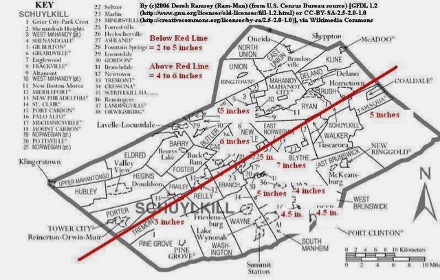
Schuylkill escaped the first two storms this past week without much ado but we finally got our due Saturday with snow & sleet. My accumulations worked out quite well from yesterday's map. Now it's time for a rest.

Later Sunday we clear out and Monday stays dry and cold. Milder weather later this coming week. A small dose of mainly very light snow is possible Tuesday but looking minor (if it even happens) at this point.

Amber Alert issued For Child Abduction in Carbon County

Amber Alert issued For Child Abduction in Carbon County

Saturday at approx. 6:30pm Kyleigh Simcsuk, age 4, was abducted from Delaware Ave. in Palmerton.  State Police said the police was abducted by Timothy Simcsuk, age 25.

Police are looking for a dark green mini-van with either PA or California registration.

Direction of travel is unknown.

Schuylkill County Boroughs with Snow Emergencies

The following borough(s) declared a SNOW EMERGENCY

Ashland

ASHLAND BOROUGH HAS DECLARED A SNOW EMERGENCY:

EFFECTIVE SUNDAY DECEMBER 15, 2013 FROM 2AM TO 6AM.

Parking will be prohibited on Hoffman Boulevard from Brock Street to Centre Street and also on Centre Street from Front Street to 23rd Street.

Residents are ordered to move their cars from these locations between 2am and 6am.

Any vehicles that are not moved from the above locations will be fined $50 and towed away at the Owner's expense.

Mahanoy City

Snow Parking Ban Tonight

Mayor has issued a snow parking ban. There will be NO PARKING between Midnight & 7AM on the following streets: Centre St. , Main St. , South St from 2nd Street west to Borough line.